


Green Infrastructure
Green infrastructure is a natural life support system: an interconnected network of waterways, wetlands, woodlands, wildlife habitats, and other natural areas; greenways, parks, and other conservation lands; working farms, and forests; and wilderness; and other open spaces that support native species, maintain natural ecological processes, sustain air and water resources, and contribute to the health and quality of life for the communities and people.
- Mark Benedict and Edward McMahon, The Conservation Fund
Planning with Green Infrastructure Manual (without maps) Click here.
Individual County - Green Infrastructure Maps:
Antrim County
Benzie County
Charlevoix County
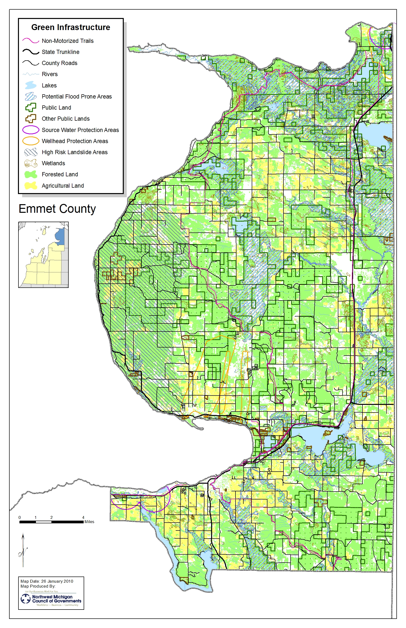
Emmet County
Grand Traverse County
Kalkaska County
Leelanau County
Manistee County
Missaukee County
Wexford County
New Designs for Growth Green Infrastructure presentation materials.
- Identify areas of ecological importance
- Green infrastructure should function as the framework for conservation and development – no isolated islands of protected lands
- Design and plan green infrastructure before development – restoring natural areas is more expensive; protect sensitive ecological areas before development occurs.
- Linkage is key – create a network of important ecological areas throughout a region; The linkages would between all levels of government and non-governmental organizations for a sufficient scope to be successful.
- Green infrastructure functions across jurisdictions and at different scales – across urban, suburban, and rural and incorporates parcels owned by private interests and local, state, federal, and tribal governments.
- Green infrastructure is grounded in sound science and land use planning theories and practices from professionals in diverse fields.
- Green infrastructure is a critical public investment – funded in the same way that the nation’s highways are funded – primary budgetary items to spread the costs of construction and maintenance across a large pool of users.
- Green infrastructure engages key partners and involves diverse stakeholders – forge alliances between public and private organizations.
- Improve the scientific basis of ecological management
- Protect globally and regionally important natural communities
- Restore natural communities to ecological health
- Manage natural communities to sustain native biodiversity
- Develop citizen awareness and understanding of local biodiversity to ensure support and participation
- Foster a sustainable relationship between society and nature in the region
- Enrich the quality of lives of the region’s citizens
- Create and manage a greenways and natural areas network
- Conserve and restore natural areas to maintain a dynamic, functioning natural landscape that provides ecological, aesthetic, and economic benefits while allowing for adaptation to future environmental changes
- Connect and enhance existing open spaces, outdoor recreational amenities and cultural resources to the regional greenways and natural areas network.
- Ensure that the greenways and natural areas network serve all residents
- Build public and private support for the greenways and natural areas network
- Fund the creation and maintenance of the regional greenways and natural areas network through public and private resources.
- Data Gathering: complete an inventory of natural assets
- Analyze the collected data
- Define a network of open lands/green spaces
- Identify the most important unprotected natural lands
- Link or connect these lands through a system of corridors
- Prioritize projects
- Target acquisitions and easements
- Design a transit system based on green infrastructure
- Define current regional employment centers/locate probable future centers
- Review water/sewer utility services and the way they serve land use patterns
- A variety of natural resources
- How a given parcel fits in a larger system
- Ecological importance of open space
- Importance of coordinated state and local planning
- Need for a regional level view for wildlife conservation
- Purchase of property for preserves
- Transfer of Development Rights (TDR)
- Purchase of Development Rights (PDR)
- Utility Service Districts
- Conservation easements
- Farmland Preservation Programs
- Trailway Plans
- Corridor Plans
- Master Plans/Zoning Ordinances
Low Impact Design: Best Practice Materials
The Southeast Michigan Council of Governments (SEMCOG) has developed an online Low Impact Development (LID) database to help communities identify LID practices throughout the state. This easy-to-use database can provide information related to all LID practices within a community, a county, neighboring communities, the region, or the State. LID practices include things such as green roofs, rain gardens, porous pavement, detention basins, constructed wetlands, preservation of riparian areas, and many others.
The database was designed to go hand-in-hand with the Michigan Low Impact Development Manual: A Design Guide for Implementers and Reviewers and currently includes all of the case studies represented in the manual.
For more information visit: www.semcog.org/data/lid.cfm
Other Links
TV 7-4 reports on the Green Infrastructure workshops in northern Michigan.


